Using the Google Earth API as a 3-D viewer for non-georectifiable old maps
[NOTE: this no longer works online, as the Google KML Gadget that supported this implementation has recently been taken offline and the Google Earth API itself is being “deprecated” (the KML does still work in Google Earth’s desktop version). This is a lesson to never be dependent on a specific tool or process – tech advancements will leave you behind.
– AGT 12/2014]
This is an experiment I did last year – it uses the Google Earth API as a viewing engine to explore a historic map, and I’m fairly happy with how it worked out.
To explore the map you need the Google Earth API installed on you browser.
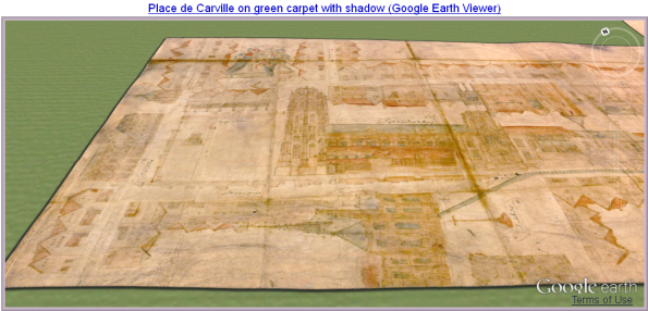
It’s easy to forget that a 2-dimensional vellum map like this was designed to be viewed in 3 dimensions, not from the Top-Down, North-is-Up perspective offered by most Desktop Computer setups (Tablets address this shortcoming somewhat because their screens can be viewed from multiple viewpoints and angles). Changing viewpoints is especially important for this map, which is drawn from multiple perspectives.
Using the Google Earth API as a map viewer restores that 3D experience. A user can look at this map from any angle and change their point of view virtually at will. This also benefits from the excellent Google Earth interface, which many people are already familiar with. Of course the Google Earth API could be used to view any flat image, not just maps. I should mention that the compass direction is accurate according to the cathedral’s location in Google Earth’s satellite image, that both the map and “carpet” are GE Overlays and that the original map is much more detailed than this overlay image (and all the text is legible).
[This version no longer works because the Google Earth API (web) was deaccessioned. However I utilized Google Earth to create the following 3D video tour of another historical map using the same concepts described here.
– High-resolution 3D video tour of Le Plan Scénographique de Lyon c. 1550
